Geological | Local > Fissures
Within the bedrock in the pit yard and the lands to the south and west are a large number of narrow fissures of unknown depth. When the pit-top was being constructed in the 1870s, a fissure was encountered during the excavations which required brick arching to be built over it in order to support the overlying structure. Fortunately, it did not run in the direction of the chimneys. In the 1960s, the pit canteen had to be rebuilt following damage due to the effects of underlying fissures and a few years later, open fissures were seen running across the railway sidings on the north side of the pit-top.
The extent of the connectivity of the fissuring was brought home when coal slurry from the unlined settling ponds constructed on the pit-tips on the higher ground to the north was found to be emerging in gardens close to the valley bottom. When the pit-tip was later landscaped following closure of the pit, rainwater run-off was found to be draining into the fissures in the former railway sidings and they had to be sealed to prevent contamination of the groundwater.
In November 2005, ground clearance work on the site of the colliery car-park exposed a section of old brick wall in which a length about 4yd long had sagged by about 12in at some time in the past. The sagging was probably due to collapes into an underlying fissure although this could not be seen at the time.
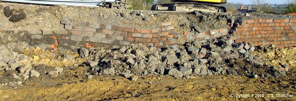

Section of disturbed brickwork near the SW edge of the old car-park area. (20/11/205)
It also exposed nearby a small fissure about 18in wide and 4ft deep. It had a NS trend and the floor appeared to consist of jammed rock debris so it may have continued much deeper. As clearance work continued, several large interconnected fissures were exposed which caused considerable problems for the site contractors, requiring extensive excavation of the bedrock and the construction of reinforced concrete rafts over them.
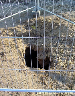
see inside the fissure
Fissure exposed during clearing work in old car-park area. (20/11/2005)


Fresh collapse of the infill at RH edge of the fissure (08/01/06).
Exposed and partly backfilled fissure (08/01/06)
During the excavations a large concrete plug was removed from the top of a fissure. It’s not known when this was plug was cast but it’s clear that at some time in the past a serious problem had occurred.

large concrete plug excavated from a fissure (08/01/06)
Fissures had been encountered during excavations for the Great Northern railway line approaching the colliery from Teversal. Several were exposed in the colliery sidings cutting to the west where they extend almost the full height of the cutting. Some were closed off with stonework (which has since been removed) but others were open and became the home to a large colony of jackdaws. They were sufficiently wide for teenage boys to penetrate inside for up to 10 feet.
see the fissures in the railway cutting
In the 1960s problems began to occur with properties in New Terrace, Upper Pleasley, a few hundred yards to the south of the pit-top, where cracking started to appear in the walls of houses. Investigation revealed the presence of a number of fissures running in a NNE - SSW direction and extending for some distance under other nearby houses.
At about the same time a hole opened in a field about 1/2 mile further to the west to reveal a NNW - SSE trending fissure which could be descended for 8 - 10 ft. A smaller hole with a similar trend later opened in the old railway track just north of the pit-top. These holes revealed the presence of pre-existing fissures 15 - 20 in wide, extending for an unknown distance and with only a thin surface seal just below soil level.
Although the National Coal Board denied any responsibility, there were workings active below these areas around that time. In December 1967, Pleasley opened a new face in the 1st Waterloo seam about 120 yds South of New Terrace. To the West, Pleasley had worked the Dunsil seam in the mid 1950s and Teversal opened a nearby face in the same seam in 1963. Whilst no subsidence as such appears to have been recorded, the angle of draw from these faces brings this area within the zone of potential disturbance and suggest that there may have been sufficient impact at the surface to allow the unconsolidated material sealing the top of the fissure to collapse.
Some indication of the extent of the fissuring to the south-west of the colliery is shown in an aerial photograph taken in May 1989. In the fields about 3/4 mile away crop-marks appear to reveal the presence of an extensive network of interconnected features running along the rim of a small valley and extending between the cuttings of the LMS and LNER railway lines. In the image below, the course of the LMS railway runs diagonally across the RH side with the LNER track just visible in the RH corner. A geophysical survey will be required in order to confirm this, however. The crop marks seem to follow the trend of a tributary valley. The valley contains a small stream following the exposure of the Middle Coal Measures strata which outcrops in the valley just beyond the LH side of the photo, the junction with the overlying Permian being marked by a line of springs
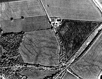
Crop marks about 3/4 mile SW of the colliery. May 1989. (FoPP/JST)
Around 2005 another fissure appeared in the front garden of a house in New Terrace, Upper Pleasley. It was about 12 inches wide, clear of debris and extending to a depth which could not be determined - the sides remaining parallel as far as could be seen. The trend was NE-SW and the dip was vertical. The length exposed was about 8 ft and at either end it was sealed by what appeared to be a layer of clayey - sandy soil about 12-15 in thick resting on rock rubble. The side walls appeared to have a fairly smooth surface, slightly undulating over a distance of a few feet with some suggestion of a veneer of flow-stone.
Problems with fissures in the Magnesian Limestone were not confined to Pleasley in the 1960s, however. In the 1890s, Stanton Ironworks Co. had to rebuild Skegby church and vicarage after these are been damaged by subsidence caused by the advancing workings in the Top Hard seam from Teversal colliery. The principle reason for the damage was identified as being due to the presence of pre-existing concealed fissures in the Magnesian Limestone ranging from 2 to 12 feet wide. Several other similar cases occurred at Pleasley and in every instance when the foundations of the damaged buildings were examined it was found that concealed fissures were the principal cause of the damage.
In the early 1900s, Shirebrook colliery workings in the Top Hard seam resulted in considerable damage to nearby Stuffynwood Hall although other nearby properties were not affected. This damage was believed to be due to subsidence disturbing pre-existing fissures in the Magnesian Limestone running beneath the hall.
About a mile to the east of the colliery, in a railway cutting above the old Pleasley Vale cotton mills situated on the river Meden, there is a “cave” commonly known locally as “Yew Tree Cave”. (NB this is not the cave referred to in the 19th century where prehistoric animal remains were found). The cave consists of a series of tall vertical-sided passageways running into the hillside intersected by lower cross-cutting ones, and by a set of very low horizontal passages. The actual extent of the cave is unknown but in my early twenties, by sliding along a narrow horizontal slot and corkscrewing through a tiny aperture in the side, I penetrated into a large vertical chamber about 4 ft. wide with a sloping clay floor and walls extending upward for a considerable distance. There were two other vertical chambers of a similar dimension intersecting the main one.
The roof of the chambers, which must have been close to the surface, appeared to be composed of jammed blocks and clay and looked distinctly unstable. As there was no possibility of rescue by the route I had entered should I be cut off by a roof collapse, discretion ruled the day and I retreated without going any further. When I got back to the small aperture, however, I found that my friend, who was broader across the chest than me, had got stuck in the hole. Panic time!! I went back into the big chamber and left him to it, whilst I considered the possibility of digging my way out to the surface. Luckily he eventually managed to extricate himself and returned to the main entrance chamber. When I came to squeeze back through the aperture it really was tight and I had to take my T-shirt off to get through. We were lucky but I guess I would have got out eventually because after a week of starvation he would either have slimmed down or I would have eaten him.
One of the strangest things about this “cave” is that in one of the lower horizontal passageways (about 15 ft. below the entrance) there was a complete section of iron fence railing often seen around nearby fields lying pinned underneath a massive block of stone. Just how this came to be there was difficult to understand and even now I sometimes wonder whether I imagined it, it’s so hard to believe. The railing was about 8 ft. long by 4 ft. wide, laid on it’s side whilst the block of stone measured maybe 12 ft. long, 8 ft. high and at least 5 ft. deep, possibly more. The climb down to this point involved passages about 2 ft. high by 30 in. wide and there was no possibility that it could have been manipulated there and slotted underneath the block, even if it had been got through the small triangular entrance.
Looking back, in the light of my understanding of the nature and extent of the fissuring within the limestone strata forming the sides of the river valley in this area, and a better understanding of geomorphological processes, I have come up with an explanation for this seeming impossibility. The “cave” is located on a bend of the single-track Midland Railway branch line cut through the brow of the hillside above the cotton mills in the valley bottom. The cutting is not particularly narrow and the sides for much of its length consist of rocky outcrops. At this point, however, on the uphill side, the outcropping rock is set back some distance from the track-side and is approached via gently rising open ground. As the “cave” entrance is approached, however, the ground steepens before a rock face enclosing a shallow amphitheater is encountered. The overall appearance suggests that the entrance to the cave may have been exposed by a land slip and this may give a clue as to how the “cave” was formed and how the railings got there.
It may be that the uphill side of the cutting was quarried back during the excavation work in order to provide stone for constructing the nearby bridges and walls and once finished with, a fence would have been erected along the top of the quarried face to reinstate the field enclosure. The quarry floor would probably have been close to the level of the floor of the cutting and, if the excavation had approached close to an area with the kind of substantial fissuring seen inside the “cave”, it’s quite conceivable that the back-wall of the quarry could have, at some point, suffered a catastrophic top-down collapse. This could have thrown the iron fencing to the bottom before precipitating the massive blocks on top of it, the whole pile forming the ramp up to the current entrance with the cavities between them forming the interconnecting horizontal passages.
When this happened (if it did happen) is not known although there may be some record of it in the Portland estate papers. What may have induced the collapse is not too hard to understand, however. The Stanton Ironworks records show that, whilst the Pleasley workings in the Top Hard seam had stopped at the western boundary of the pillar of coal left to protect the Pleasley Vale cotton mills, the actual subsidence had extended some distance beyond this point and had damaged the walls of the upper dam holding the water used to power the mill. In fact they state that the whole of the valley above this point had been lowered by about three feet and if a similar impact was created as the workings approached the southern boundary of the pillar, movement of a potentially unstable rock face located adjacent to it could well have occurred.
Sources
- J.A.Longden, Trans. Fed. Inst. Min. Eng ?
- Jno. Piggford, Trans. Inst. Min. Eng., 1908 Vol xxxvi
- W. Hay, Trans. Inst. Min. Eng., 1908 Vol xxxvi
- Shadbolt, Ph.D. Thesis, Nottingham University, 1987
- Stanton Ironworks Co. Minutes, Derbyshire County Records Office
Copyright © 2005 - 2020 J.S. Thatcher
Page updated on:
29 Jul, 2020
at
07:44:24 PM
In case of problems contact: